OGC is globally known for its proven widely implemented open standards. The OGC open consensus-based standards development process has evolved to move at the pace of innovation, with constant input from technology forecasting, practical prototyping, real-world testing, certification and compliance and community engagement. Today we are revolutionizing how geospatial/location information is shared, accessed, integrated, and analyzed via the OGC’s revolutionary APIs- the building blocks for location information.

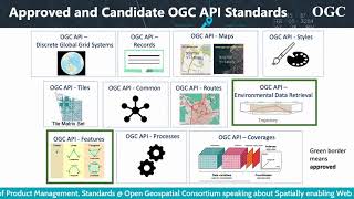
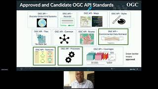
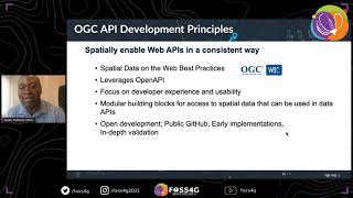
OGC APIs are designed to make it easy for ANYONE to provide and use geospatial data on the web, and to integrate this data with ANY other type of information. These Standards build upon the legacy of the OGC Web Service Standards (WMS, WFS, WCS, WPS, etc.), but define resource-centric APIs that take advantage of modern web development practices. This web page provides information on these Standards in a consolidated location.

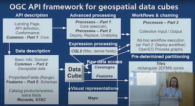
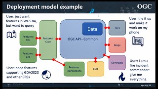
These Standards are being constructed as "building blocks" that can be used to assemble novel APIs for web access to geospatial content. The building blocks are defined not only by the requirements of the Standards specified in the OGC's Standards Program, but also through interoperability prototyping and testing in the OGC's Collaborative Solutions and Innovation Program.
To learn more about using the OGC APIs please view our guidelines here.

The OGC API Roadmap highlights the current and planned standards efforts as well as related extensions to those standards. The roadmap is available for the public to view. Request access here.

For more information on the OGC API standards, please contact us using the form below.

To find out more about the OGC please visit our public site. OGC Logo

What's New

OGC API standards in the news

2024 Joint OGC ASF OSGeo Code Sprint
Registration opened for the OGC API - Coverages Virtual Code Sprint

The Open Geospatial Consortium (OGC) invites developers to the 2024 OGC API - Coverages Virtual Code Sprint to be held from the 13th to 15th February 2024, on GoToMeeting and Gitter online platforms. This virtual only event aims to advance the OGC API - Coverages candidate Standard by providing an opportunity for developers to focus on implementation of the candidate Standard over a period of three days.


More Info

Maps public comment
OGC Seeks Public Comment on OGC API - Maps - Part 1: Core Candidate Standard

The Open Geospatial Consortium (OGC) seeks public comment on the candidate OGC API - Maps - Part 1: Core Standard. Comments are due by March 6, 2024. The OGC API - Maps - Part 1: Core Standard defines a Web API that can serve spatially referenced electronic maps, whether they are static or rendered dynamically, in a manner independent of the underlying data store.


More Info

2024 Joint OGC ASF OSGeo Code Sprint
Registration opened for the Joint OGC ASF OSGeo Code Sprint

The Open Geospatial Consortium (OGC), Apache Software Foundation (ASF), and Open Source Geospatial Foundation (OSGeo) are pleased to announce the date of the 4th annual Joint OGC ASF OSGeo Code Sprint. The code sprint will be held from the 26th to 28th February 2024 as a hybrid event supporting both face-to-face and remote participation. The face-to-face component will be held in Casa Cordovil-Universidade de Évora (Évora, Portugal), while the virtual component will be held in the OGC Events discord server.


More Info

APIs for the Web

Features

Approved Standard

OGC API - Features - Part 1: Core and Part 2: Coordinate Reference Systems by Reference are both publicly available.

Common

Approved Standard

OGC API - Common specifies those building blocks that are shared by most or all OGC API Standards to ensure consistency across the family.

EDR

Approved Standard

Environmental Data Retrieval (EDR) API provides a family of lightweight interfaces to access Environmental Data resources. Each resource addressed by an EDR API maps to a defined query pattern.

Tiles

Approved Standard

OGC API - Tiles provides extended functionality to other OGC API Standards to deliver vector tiles, map tiles, and other tiled data.

Processes

Approved Standard

OGC API - Processes allows for processing tools to be called and combined from many sources and applied to data in other OGC API resources though a simple API.

Coverages

OGC API - Coverages allows discovery, visualization and query of complex raster stacks and data cubes.

Records

OGC API - Records updates OGC’s Catalog Services for the Web by building on the simple access to content in OGC API - Features.

Styles

The OGC API - Styles defines a Web API that enables map servers, clients as well as visual style editors, to manage and fetch styles.

Maps

OGC API - Maps offers a modern approach to the OGC Web Map Service (WMS) standard for provision map and raster content.

DGGS

Enables applications to organise and access data arranged according to a Discrete Global Grid System (DGGS).

Routes

Enables applications to request routes in a manner independent of the underlying routing data set, routing engine or algorithm.

Photo by pepe nero on Unsplash
Joins

OGC API - Joins supports the joining of data, from multiple sources, with feature collections or directly with other input files.

Photo by kimi lee on Unsplash
Moving Features

OGC API - Moving Features defines an API that provides access to data representing features that move as rigid bodies.

Image by Brecht Corbeel on Unsplash
3D GeoVolumes

OGC API - 3D GeoVolumes facilitates efficient discovery of and access to 3D content in multiple formats based on a space-centric perspective.

Image by Daniam Chou on Unsplash
Connected Systems

OGC API - Connected Systems act as a bridge between static and dynamic data collected by sensors.


APIs for the IoT

Photo by kimi lee on Unsplash
SensorThings

The OGC SensorThings API provides an open, geospatial-enabled and unified way to interconnect Internet of Things (IoT) devices, data, and applications over the Web.


Compliance Testing and Certification

The executable test suite for Parts 1 and 2 of the OGC API - Features Standard 1.0 is now available.

The executable test suite for the OGC API - Environmental Data Retrieval Standard 1.0 is now available.

The executable test suite for the OGC API - Processes Standard 1.0 is now available.

More information about Compliance certification is on the OGC website.

Sprints

OGC continues to use special events, hackathons, and sprints to validate the OGC API draft candidate standards as those standards evolve. By including the broadest possible selection of stakeholders, OGC can be confident that when the standards are published, those standards have already withstood testing and suitability evaluation.

  • OGC API - Coverages Virtual Code Sprint

    13 February to 15 February. This will be a virtual only event. The virtual code sprint aims to advance the OGC API - Coverages candidate Standard by providing an opportunity for developers to focus on implementation of the candidate Standard over a period of three days.


    Registration is Open

  • Joint OGC ASF OSGeo Code Sprint

    26 February to 28 February. This will be a hybrid event. The face-to-face element will be held in Évora, Portugal. The code sprint will cover several OGC Standards, Apache projects, and OSGeo projects.


    Registration is Open

OGC Web API guidelines

The OGC Architecture Board (OAB) considers architecture consistency and life cycle management of the OGC standards baseline. The OAB has developed OGC Web API Guidelines to be followed when building Web API standards. These guidelines are not mandatory or policy, rather their purpose is to assist standards developers to use common patterns and better align their efforts.

OGC API Videos

Click on a video below to begin viewing it.

video
Getting Geospatial Data on the Web
video
OGC APIs: The Building Blocks for Location
video
OGC API Overview and Implementation
video
OGC API update - presented to the ESIP - November 2020
video
FOSS4G 2021 - OGC APIs: background, current state, what's next?
video
Apidays LIVE interface 2021 - Spatially enabling Web APIs through OGC Standards By Gobe Hobona
video
ApacheCon 2021 - OGC APIs: Web API Standards for Handling and Exchanging Location Data - Gobe Hobona, Scott Simmons

Training for Getting Started

A series of freely accessible e-learning and training resources for getting started with OGC API Standards.
For advanced training, please contact OGC Members.

Show more +

Supporting Documents

OGC and other documents supporting OGC API efforts.

The OGC API standards rely heavily upon fundamental concepts expressed in OGC White Papers and research and testing performed in OGC's Collaborative Solutions and Innovation Program activities and documented in Engineering Reports. OGC members are also specifying best practices for the use of web APIs and often share that guidance. The documents below provide some background to OGC API efforts.

ICA extended abstract: OGC API Standards for the Next Generation of Web Mapping OpenAPI Initiative article: Why the Largest Geospatial Organization in the World Uses the OpenAPI Specification OGC Testbed-18: Reproducible FAIR Best Practices Engineering Report OGC Testbed-18: Secure Asynchronous Catalog Engineering Report OGC Testbed-18: Machine Learning Training Data Engineering Report OGC Testbed-18: Identifiers for Reproducible Science Summary Engineering Report OGC Testbed-18: Filtering Service and Rule Set Engineering Report OGC Testbed-17: Geo Data Cube API Engineering Report OGC Testbed-17: Aviation API Engineering Report OGC Testbed-17: Data Centric Security Engineering Report OGC Testbed-17: Attracting Developers: Lowering the entry barrier for implementing OGC Web APIs Engineering Report OGC Testbed-17: OGC API - Moving Features Engineering Report Joint OGC and ISO Code Sprint 2022 Summary Engineering Report Joint OGC OSGeo ASF Code Sprint 2022 Summary Engineering Report July 2021 OGC API Code Sprint Summary Engineering Report May 2021 OGC API Code Sprint Summary Engineering Report Joint OGC OSGeo ASF Code Sprint 2021 Summary Engineering Report OGC API – Common and OGC API – Features Sprint 2020: Summary Engineering Report OGC API – Maps Sprint 2020: Summary Engineering Report OGC Testbed-16: OpenAPI Engineering Report OGC Testbed-16: Data Centric Security Engineering Report OGC Testbed-16: OpenAPI Engineering Report OGC Testbed-16: DGGS and DGGS API Engineering Report OGC Testbed-16: Data Access and Processing Engineering Report OGC Testbed-16: Data Access and Processing API Engineering Report OGC Testbed-16: Machine Learning Training Data ER OGC Testbed-16: Aviation Engineering Report OGC Testbed-16: Earth Observation Application Packages with Jupyter Notebooks OGC Vector Tiles Pilot 2: Summary Engineering Report OGC Vector Tiles Pilot 2: Tile Set Metadata Engineering Report OGC Vector Tiles Pilot 2: Vector Tiles Filtering Language Engineering Report FGDC OGC Application Programming Interface Interoperability Assessment OGC API Prospectus Testbed-15 Styles API Engineering Report Testbed-15 Maps and Tiles API Engineering Report Testbed-15 Images and Changes Set API Engineering Report OGC Open Geospatial APIs - White Paper Joint OGC-W3C Spatial Data on the Web Best Practices OGC Testbed-14: Next Generation Web APIs - WFS 3.0 Engineering Report OGC Testbed-14 Next Generation APIs: Complex Feature Handling Engineering Report OGC Testbed-14: Application Package Engineering Report OGC Testbed-14: ADES & EMS Results and Best Practices Engineering Report OGC Testbed-14: Swath Coverage Engineering Report OGC Vector Tiles Pilot: WFS 3.0 Vector Tiles Extension Engineering Report Vector Tiles Pilot Extension Engineering Report API strategie voor de Nederlandse overheid (section in English)
Show more +


Collaborative Solutions and Innovation Program activities

The OGC Collaborative Solutions and Innovation Program provides a world-recognized process for users of geospatial technology to collaborate and share the advancement of technologies for future enterprise architectures.

If you have an idea for an initiative or simply have a question or comment, contact Ingo Simonis, Chief Technology Innovation Officer.


Frequently Asked Questions (FAQs)

The following are frequently asked questions in relation to OGC API Standards.

  • Q: I would like to migrate from a Web Feature Service (WFS) to OGC API Standards. Which OGC API Standard should I implement?
    A: OGC API - Features
  • Q: I would like to migrate from a MetOcean Web Coverage Service (WCS) to OGC API Standards. Which OGC API Standard should I implement?
    A: OGC API - Environmental Data Retrieval
  • Q: I would like to migrate from a Web Processing Service (WPS) to OGC API Standards. Which OGC API Standard should I implement?
    A: OGC API - Processes
  • Q: I would like to migrate from a Web Map Tile Service (WMTS) to OGC API Standards. Which OGC API Standard should I implement?
    A: OGC API - Tiles
  • Q: I would like to migrate from a Sensor Observation Service (SOS) to OGC API Standards. Which OGC API Standard should I implement?
    A: OGC SensorThings API

Use of OpenAPI in legacy OGC standards

While the OGC API standards are being developed in concert around common core elements, some older OGC web service standards have been described using OpenAPI. Examples of these legacy enhancements are found below.

Get In Touch

Do you consent to the use of cookies on this site?

Set Specific Preferences